Ghana, the Kingdom of Wagadu on the Edge of the Sahara
By Princewill Ubani · Published
Research ID: PA-POL-ghana-empire
The kingdom of the western Sahel that Arabic writers called the land of gold, described in detail in 1068, long said to have been conquered by the Almoravids in 1076, and still a named province of Mali in the 1330s.

“Ghana is a title given to their kings,” the Andalusian geographer al-Bakri wrote; “the name of the region is Awkar.” Arabic writers used the word for the king, for his city and for his realm, a kingdom in the western Sahel between the Senegal and Niger rivers, in what is now southeastern Mauritania and western Mali.1 Soninke oral tradition remembers a kingdom called Wagadu, which the historian Nehemia Levtzion judged “very likely” to be the same state.2 From the late eighth century, Muslim geographers knew it as the land of gold.3
Al-Bakri finished his description in 1068 without leaving Spain, working from the reports of merchants who had been there. Levtzion called it “among the most detailed accounts of an urban centre in the Western Sudan.”4 For half a century after 1912, histories of Africa also told how Ghana ended: Almoravid warriors from the Sahara stormed its capital in 1076, massacred its people and forced the survivors to become Muslims. Since the 1980s, historians have taken that story apart. No Arabic writer describes the conquest until the 15th century, and the version the textbooks repeated was assembled in Europe, in its final form by the French scholar Maurice Delafosse in 1912.5 Ghana outlived the Almoravids. In the 1330s, a writer in Cairo recorded that its ruler was the only one of Mali’s subject princes still allowed the title of king.6
Before Ghana
Along the Dhar Tichitt, a line of sandstone cliffs in southeastern Mauritania, farmers and herders built villages of dry stone. The archaeologist Augustin Holl mapped 46 sites in his survey area alone, and the largest, Site 38, covered 12 hectares and held 200 compounds. Bulrush millet was the only cultivated plant found, and people herded cattle, sheep and goats.7 Holl puts the occupation, in radiocarbon years, from about 3850 to 2170 before the present, ending as the land dried out.8
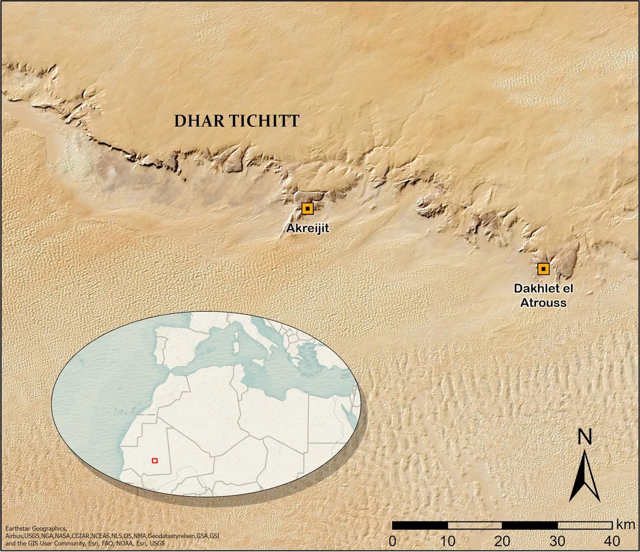
Whether those villages led to Ghana is disputed. Patrick Munson argued in 1980 that Ghana “had in turn arisen from the remains of a still earlier, prehistoric system,” a Tichitt chiefdom broken up by Berber raiders from the north.9 Holl found a gap of 600 to 800 years between the Tichitt record and the earliest remains of medieval Ghana, and wrote that “we must avoid making a direct link between Dhar Tichitt and the Ghana Empire.” He blamed the gap on the lack of any survey of the land in between.10
Michael Gomez calls Dhar Tichitt a likely cradle of the Soninke. By his reckoning, Ghana existed as an independent kingdom from about 300 CE, which would give it, with its later phases, a life of more than a thousand years.11 Farther south, excavations at Jenne-jeno on the inland Niger delta found settlement from about 250 BC and a town by AD 400, long before the medieval trade across the Sahara. Holl and the excavators used such finds against the older view that West African towns and states grew out of trade with North Africa.12
The land of gold
Arabic geography first names Ghana in the work of al-Fazari, toward the end of the eighth century.13 In 872, al-Ya’qubi listed it among the kingdoms of the Sudan, the Arabic name for the lands south of the Sahara: “Then there is the kingdom of Ghana, whose king is also very powerful. In his country are the gold mines, and under his authority are a number of kings.”14 In the 10th century Ibn Hawqal called its king “the wealthiest king on the face of the earth,” and noted that Ghana depended on the salt that reached it through Awdaghust, a caravan town in the desert to the north.15
The gold did not come from Ghana’s own land. François-Xavier Fauvelle points out that there was no gold mine in the part of Mauritania where the kingdom lay.16 The best gold, al-Bakri was told, came from Ghiyaru, 18 days’ travel from the king’s town. The historian Timothy Garrard names the goldfields of Bambuk, between the Senegal and its tributary the Faleme, as Ghana’s principal supplier. In Levtzion’s reading, Ghana’s kings drew their income from controlling the routes to the gold, not from the mines.17
Al-Bakri reported a royal rule on nuggets: “The nuggets found in all the mines of his country are reserved for the king, only this gold dust being left for the people. But for this the people would accumulate gold until it lost its value.” Levtzion read the rule as a claim on the largest share of the gold rather than a way of managing its price.18 Ghana’s gold is often tied to stories of a silent trade, in which buyers and sellers never met. Garrard notes that accounts of such a trade “have now been largely discredited.”19
The court of Tunka Manin
In 1068, al-Bakri wrote, the king was Tunka Manin, who had come to the throne in 1063. His predecessor was Basi, who had become king at 85. Basi was Tunka Manin’s maternal uncle, because in Ghana, al-Bakri explained, “only the son of the king’s sister inherits the kingship.” The king “has no doubt that his successor is a son of his sister, while he is not certain that his son is in fact his own.”20 Levtzion doubted that this was the rule: the Soninke were patrilineal, and the evidence for inheritance through the sister rests on al-Bakri alone.21
The king held audience in a domed pavilion, surrounded by ten horses in gold-embroidered cloth, with pages holding gold-decorated shields and swords behind him. On his right sat the sons of the vassal kings of his country, their hair plaited with gold. Dogs guarded the door in collars of gold and silver, and a drum called the duba announced the audience. Followers of the king’s religion greeted him on their knees and sprinkled dust on their heads; Muslims clapped their hands.22
The king kept the religion of his ancestors, but his interpreters, the official in charge of his treasury and most of his ministers were Muslims.23 Near the royal town were domed buildings and sacred groves, where priests lived and where the kings were buried. “These woods are guarded and none may enter them and know what is there,” al-Bakri wrote. The king’s prisons were there too: “If somebody is imprisoned there no news of him is ever heard again.”24 When a king died, a great dome of wood was built over his grave, and his ornaments, weapons and food were laid beside him, with the men who had served his meals.25
According to al-Bakri, the king could “put 200,000 men into the field, more than 40,000 of them archers.” Gomez notes that it is not clear whether the figure includes the camel riders of Awdaghust, and that it may describe a force raised in an emergency rather than a standing army.26
Two towns and a grove
“The city of Ghana consists of two towns situated on a plain,” al-Bakri wrote. The Muslim town was large and had 12 mosques, with salaried imams and muezzins, jurists and scholars. The king’s town, which bore the name “The Forest” (al-Ghaba), was 6 miles away, and “between these two towns there are continuous habitations.” The houses were built of stone and acacia wood, and the king had a palace and domed dwellings inside a wall.27
Modern writers have questioned the picture. Fauvelle suggests that al-Bakri’s informants, merchants who dealt with the royal court and little else, saw a city of two poles where there was a spread of villages, royal quarters and a trading center, with more empty space than built.28 Gomez writes that the archaeological literature questions a divided capital, “as does my own assessment.”29
Salt, copper and the road north
Al-Bakri recorded the king’s tolls: “On every donkey-load of salt when it is brought into the country their king levies one golden dinar, and two dinars when it is sent out. From a load of copper the king’s due is five mithqals, and from a load of other goods ten mithqals.” He named no tax on gold leaving the country.30 Levtzion explained the double rate on salt going out: some of it was carried on south to the goldfields, where it was worth far more.31
Much of Ghana’s trade with the north passed through Awdaghust, 15 days’ travel away. Al-Bakri described it as a large, crowded town with a Friday mosque and many smaller ones, a market so noisy that a man could hardly hear the person next to him, and transactions in gold because there was no silver.32 Most of its people came from Ifriqiya, in North Africa. Al-Bakri also said that Awdaghust had once been the residence of the king of Ghana.33
In 1054-55 the Almoravids, a Berber movement of religious reform from the western Sahara, took Awdaghust. “The Almoravids persecuted the people of Awdaghust only because they recognized the authority of the ruler of Ghana,” al-Bakri wrote.34 The site of Tegdaoust in southern Mauritania is usually taken to be Awdaghust, although its excavator Denise Robert wrote that there was no conclusive proof.35 The digs there, which began in 1960, found that the town survived the Almoravid attack. Jean Devisse, who led the project, wrote that no decisive evidence showed the raid of 1055 caused the break between its layers.36 Under a kitchen floor, Robert found five gold bars, which she thought were probably the first ingots found on a medieval site in West Africa.37
The conquest that never was
The Almoravids went on to conquer the Maghrib, founding Marrakesh in 1070. Their military leader, Abu Bakr b. Umar, handed command in the north to his cousin Yusuf b. Tashfin and returned to the desert, where he died in 1087. In the older histories, he stormed the capital of Ghana in 1076.38 The case rested on two passages, one by al-Zuhri in the 12th century and one by Ibn Khaldun in the 14th.39
In 1982 and 1983, David Conrad and Humphrey Fisher went through every Arabic source on the question. Al-Zuhri, they showed, describes a conversion, not a conquest. He says Ghana’s people turned Muslim at the emergence of an Almoravid amir, using a word, khuruj, that they found cannot mean conquest. Even his date is uncertain: most manuscripts read 469 AH, which is 1076-77, but the printed Arabic text reads 496 AH, or 1102-03, and Conrad and Fisher preferred the later date.40 Al-Zuhri also wrote that the people of Ghana later asked the Almoravids for help in a war with two neighboring towns. That, Conrad and Fisher argued, makes little sense if the Almoravids had just conquered them.41
Other evidence pointed the same way. A 12th-century source quotes a letter from Ghana’s king to Yusuf b. Tashfin in which the king writes in his own right; Fisher reads it as a sign of some equality between them.42 Writers who told Abu Bakr’s life in detail recorded his death by an arrow without mentioning Ghana.43 Ibn Khaldun wrote that the veiled Berbers extended their power over the Sudan, took tribute and converted many, but he kept Ghana’s own rulers in place until the Susu overcame them a century later.44 The first writer to say plainly that the veiled Berbers defeated the king of Ghana was al-Maqrizi, in the 15th century, almost four centuries after the event, and he was working from Ibn Khaldun.45 “To summarize the summary,” Conrad and Fisher wrote, “there was no Almoravid conquest of ancient Ghana.”46
In 1996, Pekka Masonen and Fisher traced how the story grew. William Desborough Cooley, writing in London in 1841, took the date from one source and the violence from others. William de Slane’s 1850s French translation of Ibn Khaldun added a “devastation” not in the Arabic. Delafosse, in 1912, turned the pieces into a full conquest, with the city taken, its people massacred and Ghana’s lands annexed as far as the gold of Bambuk, citing no source. “The conquest hypothesis is a European creation,” they concluded.47 Two centuries before Cooley, in 1615, the scholar Ahmad Baba, asked by the people of Tuwat whether the Sudan had been conquered for Islam, insisted that its people became Muslims “without being conquered by anybody.”48
Fauvelle calls Conrad and Fisher’s view “nowadays generally accepted,” though he notes that Levtzion remained unconvinced.49 Sheryl Burkhalter criticized their method in 1992 without claiming that the conquest took place.50 Gomez writes that something dramatic did happen after 1063, and that “scholars are not agreed as to precisely what that may have been.” His firm conclusion is that by 1076-77 Ghana was a Muslim state.51
A Muslim kingdom on the river
In 1154, writing in Sicily for King Roger II, al-Idrisi described a Ghana that was very much alive. It was “the greatest of all the towns of the Sudan in respect of area, the most populous, and with the most extensive trade.” Its king was a Muslim who had the Friday sermon read in his own name, paid allegiance to the Abbasid caliph and claimed descent from the Prophet’s family, a claim modern editors doubt. His palace, built in 1116-17, held a brick of gold that al-Idrisi said weighed thirty pounds.52 Towns near the goldfields paid him taxes.53
Al-Idrisi also put Ghana astride a river, as two towns on its two banks, where al-Bakri had placed it on a plain. Earlier historians tended to dismiss this as a mistake. Fauvelle argues that the capital may have moved south, or that a southern vassal may have taken the title of Ghana, and complains that no one has looked for al-Idrisi’s city.54 Gomez calls this period “resurgent Ghana” and writes that there were in fact “kingdoms of Ghana,” not one.55
Around 1200, the Almohad governor of Sijilmasa, a gateway town at the northern edge of the Sahara, wrote to “the king of the Sudan in Ghana” to complain that traders were being held. “We are neighbors in benevolence even if we differ in religion,” he wrote. Levtzion inferred that the king was by then a non-Muslim ruler of the Susu, who had taken Ghana.56
Under the Susu and Mali
Ibn Khaldun, writing in the late 14th century, is the first Arabic writer to name the Susu. “Then the authority of the rulers of Ghana dwindled away,” he wrote, “and they were overcome by the Susu, a neighboring people of the Sudan, who subjugated and absorbed them.”57 Mali’s founder, whom he called Mari Jata, then “vanquished the Susu and acquired all their possessions, both their ancient kingdom and that of Ghana as far as the ocean on the west.”58 Levtzion wrote that Muslim traders fled the Susu king Sumanguru, the Sumaoro of the Mande epic, for Walata, which replaced both Awdaghust and Ghana as the main terminus of the caravans.59
The dates in the textbooks come from inference. The usual date of 1203 for the Susu conquest rests, as Conrad and Fisher noted, on little more than the approximate date of the Sijilmasa letter.60 The date of 1240 for Ghana’s destruction by Mali is Delafosse’s. The historian Djibril Tamsir Niane rejected it on the evidence of al-Umari.61
Al-Umari, writing in Cairo in about 1336, listed Ghana first among the provinces of Mali. “In the whole kingdom of this sovereign there is none who is given the title of ‘king’ except the ruler of Ghana who is like a deputy to him even though he is a king,” he wrote.62 In 1394 Ibn Khaldun took his history of Mali from Shaykh Uthman, a jurist of Ghana visiting Cairo.63 Gomez counts three regimes in all, the old kingdom, the reformed Muslim state and the province under Mali, and finds the best marker of Ghana’s end in the abandonment of the mosque at Koumbi Saleh in the 15th century.64
Koumbi Saleh
The ruins most often identified as Ghana’s capital lie at Koumbi Saleh, in the Hodh of southeastern Mauritania near the border with Mali.65 Delafosse first pointed to the site because the Timbuktu chronicles speak of a capital called Kumbi, and two places in the area, Koumbi Saleh and Koumbi Dioufi, still carry the name. In 1914 a colonial official, Albert Bonnel de Mézières, was guided there by people from Walata and cleared several buildings and tombs, including the Column Tomb, and declared it the Ghana of the Arabic geographers because of its size and fine stonework.66
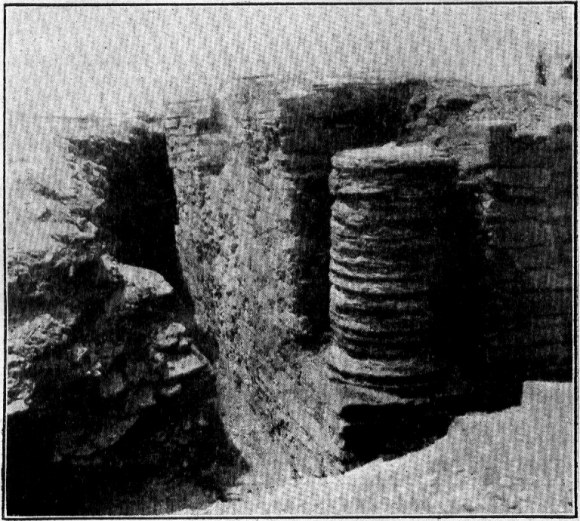
Raymond Mauny excavated there from 1949 to 1951, and his conviction that Koumbi Saleh was Ghana’s capital became, in the account of the site’s later excavator Sophie Berthier, an accepted fact without new evidence to support it.67 Mauny called it the largest town of the medieval Sahara.68 He estimated 15,000 to 20,000 inhabitants from the density of its houses, a figure later books still cite.69
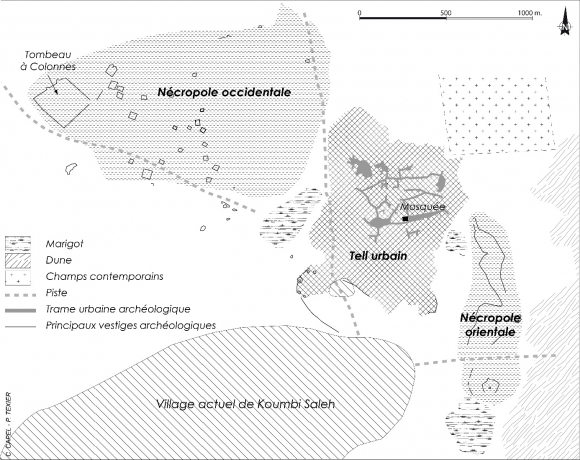
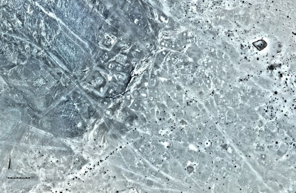
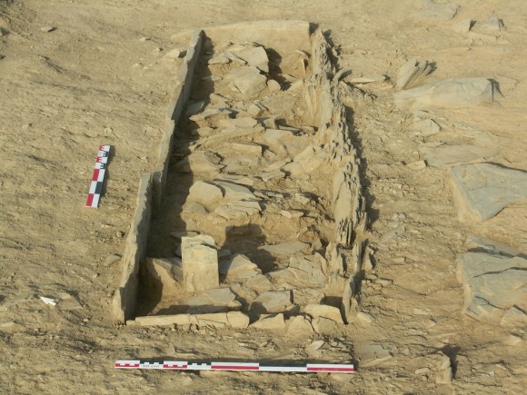
Her excavations, carried out in four seasons in 1975-76 and 1980-81, put the question on firmer ground. The urban mound covers 44 hectares inside a wall about 2.4 kilometers around. In the quarter by the mosque, 22 radiocarbon dates show continuous occupation from about the ninth century to the early 15th.70 On that evidence, she wrote, the identification of Koumbi Saleh with Ghana could only be strengthened, but only for the 11th to the early 15th century. Nothing she found was older than the late ninth century, so the Ghana that Arabic writers knew in the eighth and ninth centuries was not confirmed there, and she allowed that Ghana’s first town may have stood somewhere else.71
Timothy Insoll reads the same evidence differently. For him Koumbi Saleh is at most the merchant town, “perhaps to be identified with the merchant town attached to the as yet unlocated capital of the kingdom of Ghana.” The king’s town and its grove have not been found.72 Excavators reported signs of destruction about 5 meters down, but, as Insoll notes, even they admitted that this was no conclusive proof of an Almoravid raid.73 Fauvelle notes that surveys on foot and from the air have found no trace of a second town within miles, and concludes that anyone searching again for Ghana “would have to walk first, not dig.”74
Wagadu
The Soninke tell Ghana’s history as the story of Wagadu. Conrad and Fisher compared 17 recorded versions, collected between the 1880s and 1975.75 In the common form, a founder descended from the ancestor Dinga arrives at Kumbi and makes a pact with Bida, a great snake that guards the land: each year a young woman of Wagadu is sacrificed to it, and in return it sends rain and, in several versions, gold. At last her betrothed kills the snake. Its curse brings seven years of drought, the gold fails, Wagadu is ruined and the Soninke scatter.76
The title Kaya Magha, which later chronicles give Ghana’s kings, is glossed as “king of gold” in the Timbuktu chronicle published as the Ta’rikh al-fattash, more than five centuries after al-Bakri. No earlier Arabic source uses the phrase.77 Al-Sa’di’s chronicle of Timbuktu counts 22 kings before the Prophet’s mission and 22 after; Levtzion warned that such tidy numbers cannot be used for chronology.78
Conrad and Fisher found no Almoravid conquest in any version. The traditions blame drought for Wagadu’s fall, and the one version that describes an army of Moors at the walls of Kumbi has them turn back when they hear the call to prayer.79 The link between Wagadu and the Ghana of the Arabic writers is itself unproven. The first writer to identify the two was Louis Tautain, in 1895.80
How we know
Nearly everything written about Ghana while it existed came from outsiders. The Arabic writers lived north of the Sahara, and of those collected by Levtzion and Jay Spaulding, only Ibn Battuta visited the lands of the Sudan himself; he never mentions Ghana.81 Al-Bakri’s account came from merchants and from the lost book of a tenth-century geographer, al-Warraq.82 These texts are read in translation, and the translations differ: Levtzion and J. F. P. Hopkins give the distance between al-Bakri’s two towns as 6 miles, Mauny, working from an older French translation, as 7, and Fauvelle converts 6 Arabic miles to about a dozen kilometers.83
Archaeology has reached only part of the picture. The excavated quarter at Koumbi Saleh covers about 200 square meters of a 44-hectare mound.84 Insoll calls what was found “a rather standard trade centre,” one that sheds little light on how Ghana’s rulers became Muslim.85 The work at Tegdaoust was larger, but its excavators could not agree on the dates of its phases and printed two chronologies side by side.86
The biggest change in the last half century is the fall of the 1076 conquest. The first modern scholar to doubt it was Paul Semonin in 1964, and Mahamadou Coulibaly denied in 1974 that it ever happened, before Conrad and Fisher’s long study.87 In 1988 the UNESCO General History of Africa, in a chapter by Mohammed El Fasi and Ivan Hrbek, wrote that it was “becoming increasingly accepted that no such conquest ever took place and that the two powers in fact maintained friendly relations throughout.”88
Notes
-
Levtzion and Spaulding 2003, pp. 12, 14; Levtzion 1971, p. 126. ↩
-
Levtzion 1977, p. 379; Hunwick 2003, p. 13 n. 3; Conrad and Fisher 1983, p. 53. ↩
-
Levtzion 1973, p. 22; Levtzion 1971, p. 126. ↩
-
Levtzion and Spaulding 2003, p. 9; Levtzion 1973, pp. 22-23. ↩
-
Conrad and Fisher 1982, pp. 42-45; Masonen and Fisher 1996, pp. 197, 210-211. ↩
-
Levtzion and Spaulding 2003, pp. 50, 53-54. ↩
-
Holl 1985, pp. 88, 90, 92. ↩
-
Holl 1985, p. 88. ↩
-
Munson 1980, pp. 457, 462, 465. ↩
-
Holl 1985, pp. 108-109. ↩
-
Gomez 2018, pp. 31, 41-42. ↩
-
McIntosh and McIntosh 1980, pp. 75, 444, 446-448; Holl 1985, p. 76. ↩
-
Levtzion 1971, p. 126; Munson 1980, p. 458. ↩
-
Levtzion and Spaulding 2003, p. 2. ↩
-
Levtzion and Spaulding 2003, p. 5. ↩
-
Fauvelle 2018, p. 119. ↩
-
Levtzion and Spaulding 2003, p. 17; Garrard 1982, p. 460; Fauvelle 2018, p. 121; Levtzion 1973, p. 115. ↩
-
Levtzion and Spaulding 2003, p. 17; Levtzion 1973, p. 116. ↩
-
Garrard 1982, p. 444 n. 9. ↩
-
Levtzion and Spaulding 2003, pp. 14-15. ↩
-
Levtzion 1973, p. 110. ↩
-
Levtzion and Spaulding 2003, p. 16. ↩
-
Levtzion and Spaulding 2003, p. 15. ↩
-
Levtzion and Spaulding 2003, p. 15. ↩
-
Levtzion and Spaulding 2003, p. 16. ↩
-
Levtzion and Spaulding 2003, p. 18; Gomez 2018, p. 36. ↩
-
Levtzion and Spaulding 2003, p. 15. ↩
-
Fauvelle 2018, pp. 59-60. ↩
-
Gomez 2018, p. 384 n. 20. ↩
-
Levtzion and Spaulding 2003, p. 17; Levtzion 1973, p. 115. ↩
-
Levtzion 1973, p. 115. ↩
-
Levtzion and Spaulding 2003, pp. 11-12. ↩
-
Levtzion and Spaulding 2003, pp. 11-12. ↩
-
Levtzion and Spaulding 2003, pp. 12-13. ↩
-
Robert 1970, pp. 472, 491-493. ↩
-
Devisse 1983, pp. 197, 548; Mauny 1970, p. 194. ↩
-
Robert 1970, pp. 490-491. ↩
-
Conrad and Fisher 1982, pp. 21-22, 35, 38; Masonen and Fisher 1996, pp. 211, 225 n. 147. ↩
-
Conrad and Fisher 1982, pp. 23, 27, 38-40. ↩
-
Conrad and Fisher 1982, pp. 23-25; Fisher 1982, p. 551. ↩
-
Conrad and Fisher 1982, p. 26; Fisher 1982, p. 559. ↩
-
Conrad and Fisher 1982, pp. 29-30; Fisher 1982, pp. 558-559. ↩
-
Conrad and Fisher 1982, pp. 29, 32-34; Fisher 1982, p. 554. ↩
-
Conrad and Fisher 1982, pp. 39-40; Levtzion and Spaulding 2003, pp. 92-93. ↩
-
Conrad and Fisher 1982, pp. 42-43. ↩
-
Conrad and Fisher 1982, p. 45. ↩
-
Masonen and Fisher 1996, pp. 197, 204, 207, 210-211. ↩
-
Masonen and Fisher 1996, pp. 201-202; Conrad and Fisher 1983, p. 69. ↩
-
Fauvelle 2018, p. 67. ↩
-
Masonen and Fisher 1996, p. 219. ↩
-
Gomez 2018, pp. 37-38. ↩
-
Levtzion and Spaulding 2003, pp. 28, 32; Fauvelle 2018, p. 64. ↩
-
Levtzion and Spaulding 2003, pp. 34-35. ↩
-
Levtzion and Spaulding 2003, p. 32; Fauvelle 2018, pp. 65-67. ↩
-
Gomez 2018, p. 38. ↩
-
Levtzion and Spaulding 2003, pp. 37-38; Levtzion 1977, p. 351. ↩
-
Levtzion and Spaulding 2003, pp. 89, 93. ↩
-
Levtzion and Spaulding 2003, p. 93. ↩
-
Levtzion 1977, p. 352. ↩
-
Conrad and Fisher 1982, pp. 30-31, 51 n. 61. ↩
-
Niane 1984, p. 135 n. 44. ↩
-
Levtzion and Spaulding 2003, pp. 50, 53-54. ↩
-
Levtzion and Spaulding 2003, p. 89; Gomez 2018, p. 41. ↩
-
Gomez 2018, pp. 41-42. ↩
-
Berthier 1997, p. 1. ↩
-
Berthier 1997, p. 3. ↩
-
Berthier 1997, pp. 3, 5. ↩
-
Mauny 1961, p. 482. ↩
-
Mauny 1961, p. 482; Insoll 2003, p. 228; Gomez 2018, p. 384. ↩
-
Berthier 1997, pp. 1, 5, 27, 30. ↩
-
Berthier 1997, pp. 101, 103. ↩
-
Insoll 2003, pp. 215, 222, 228, 231. ↩
-
Insoll 2003, p. 230; Hrbek and Devisse 1988, p. 359. ↩
-
Fauvelle 2018, pp. 59, 61. ↩
-
Conrad and Fisher 1983, p. 54. ↩
-
Conrad and Fisher 1983, pp. 55, 63-64. ↩
-
Hunwick 2003, p. 13 n. 1; Conrad and Fisher 1983, p. 59; Levtzion 1971, p. 124. ↩
-
Hunwick 2003, p. 13; Levtzion 1973, pp. 19-20. ↩
-
Conrad and Fisher 1983, pp. 62, 68. ↩
-
Masonen and Fisher 1996, p. 227 n. 96; Conrad and Fisher 1983, p. 53. ↩
-
Levtzion and Spaulding 2003, p. x; Conrad and Fisher 1982, p. 38. ↩
-
Levtzion and Spaulding 2003, p. 9; Levtzion 1973, p. 22. ↩
-
Levtzion and Spaulding 2003, p. 15; Mauny 1961, p. 466; Fauvelle 2018, p. 59. ↩
-
Berthier 1997, pp. 1, 5. ↩
-
Insoll 2003, p. 229. ↩
-
Devisse 1983, p. 214. ↩
-
Masonen and Fisher 1996, pp. 216-218; Conrad and Fisher 1982, p. 46 n. 1. ↩
-
El Fasi and Hrbek 1988, p. 74. ↩
Where the estimates differ
| Estimate | Who holds it | Source |
|---|---|---|
| 469 AH (1076-77), when an Almoravid amir "made his appearance" | Most manuscripts of al-Zuhri, followed by the editors of the standard English translation | Levtzion and Spaulding 2003, p. 23 |
| 496 AH (1102-03) | The printed text of al-Zuhri; preferred by David Conrad and Humphrey Fisher | Conrad and Fisher 1982, pp. 23-25 |
| 1076, after Ghana was conquered by the Almoravids | Nehemia Levtzion | Levtzion 1977, p. 349 |
| Peacefully, probably early in the 12th century, with no conquest | David Conrad and Humphrey Fisher | Conrad and Fisher 1982, p. 45 |
| Estimate | Who holds it | Source |
|---|---|---|
| No figure: its extent "may only be guessed" | Nehemia Levtzion | Levtzion 1973, p. 27 |
| About 200,000 to 300,000 square kilometers, centered on the Aouker | Augustin Holl, who adds that the kingdom's range is not well known | Holl 1985, p. 74 |
| About 726,000 square kilometers | This site's measurement of the shading on Gomez's Map 4, which states no basis | Gomez 2018, p. 34 |
| Estimate | Who holds it | Source |
|---|---|---|
| 15,000 to 20,000 | Raymond Mauny, assuming 177 to 240 people a hectare; repeated by Levtzion, Insoll and Gomez | Mauny 1961, p. 482 |
| Several hundred, in al-Bakri's Muslim town | François-Xavier Fauvelle, reasoning from its twelve mosques | Fauvelle 2018, p. 59 |
| Estimate | Who holds it | Source |
|---|---|---|
| 1240, destroyed by Sundiata of Mali | Maurice Delafosse, rejected by Djibril Tamsir Niane on the evidence of al-Umari | Niane 1984, p. 135 n. 44 |
| Conquered by the Susu by about 1200 | Nehemia Levtzion, inferring it from a letter written to Ghana's king before 1203 | Levtzion and Spaulding 2003, p. 37 |
| A tributary of Mali for about 200 years after the early 13th century | Michael Gomez | Gomez 2018, pp. 41-42 |
| Koumbi Saleh occupied until the early 15th century | Sophie Berthier, from radiocarbon dates | Berthier 1997, p. 30 |
Rulers of Ghana
| Ruler | Reign | Note |
|---|---|---|
| Basi | unknown to 1063 | Al-Bakri says he became king at 85 and was succeeded by his sister's son. His accession year is not known. |
| Tunka Manin | 1063 to unknown | King when al-Bakri wrote in 1068. Fauvelle gives his accession as 1062. |
Timeline
- c. AD 800 Ghana emerges
- 1063 Tunka Manin begins to rule
- c. 1200 Ghana is overcome by the Susu and later absorbed by Mali; its ruler is still called king under the mansa in the 1330s
Correction
Our Ghana overview has moved into the new Ghana page, and it had the end of the story wrong.The overview at /history/articles/ghana-empire-wagadu-first-trading-state/ now redirects to the new state page. It said Ghana was absorbed into Mali around 1240. That date is Maurice Delafosse's, and D. T. Niane rejected it: al-Umari, writing in about 1336, still lists Ghana as a province of Mali whose ruler kept the title of king (Niane 1984, p. 135 n. 44; Levtzion and Spaulding 2003, p. 54). It said Tunka Manin reigned into the 1070s; al-Bakri gives only his accession in 1063 (Levtzion and Spaulding 2003, p. 14). It called Ghana the first of West Africa's three great trading states and possibly the longest-lived, and we found no source for either claim. It presented drought as the modern explanation for Ghana's decline; drought is the explanation given by the Soninke traditions themselves (Conrad and Fisher 1983, p. 68). It also captioned a plan of Koumbi Saleh as a photograph of ruins and credited it as public domain; it is a plan, licensed CC BY-SA 4.0.Corrected in September 2026. See the log entry.
Sources
- Nehemia Levtzion and Jay Spaulding (eds.). “Medieval West Africa: Views from Arab Scholars and Merchants”, Markus Wiener, 2003.
- Nehemia Levtzion. “Ancient Ghana and Mali”, Methuen, 1973.
- Michael A. Gomez. “African Dominion: A New History of Empire in Early and Medieval West Africa”, Princeton University Press, 2018.
- David Conrad and Humphrey Fisher. “The Conquest That Never Was: Ghana and the Almoravids, 1076. I. The External Arabic Sources”, History in Africa 9, 1982.
- David C. Conrad and Humphrey J. Fisher. “The Conquest That Never Was: Ghana and the Almoravids, 1076. II. The Local Oral Sources”, History in Africa 10, 1983.
- Pekka Masonen and Humphrey J. Fisher. “Not Quite Venus from the Waves: The Almoravid Conquest of Ghana in the Modern Historiography of Western Africa”, History in Africa 23, 1996.
- Sophie Berthier. “Recherches archéologiques sur la capitale de l'empire de Ghana”, BAR International Series 680, 1997.
- Timothy Insoll. “The Archaeology of Islam in Sub-Saharan Africa”, Cambridge University Press, 2003.
Further Reading
The sources above support the specific claims on this page. The works below are the scholarship behind them. Citations are given in full so readers can find them through a library or database; some are paywalled.
Peer-reviewed articles
- Levtzion, Nehemia (1979). "The Sahara and the Sudan from the Arab conquest of the Maghrib to the rise of the Almoravids." The Cambridge History of Africa, Volume 2 (Cambridge University Press), pp. 637-684 null: 637-684. DOI: 10.1017/chol9780521215923.013.
- Levtzion, Nehemia (1977). "The western Maghrib and Sudan." The Cambridge History of Africa, Volume 3 (Cambridge University Press), pp. 331-462 null: 331-462. DOI: 10.1017/chol9780521209816.007.
- Munson, Patrick J. (1980). "Archaeology and the prehistoric origins of the Ghana empire." The Journal of African History 21(4): 457-466. DOI: 10.1017/s0021853700018685.
- Holl, Augustin (1985). "Background to the Ghana empire: Archaeological investigations on the transition to statehood in the Dhar Tichitt region (mauritania)." Journal of Anthropological Archaeology 4(2): 73-115. DOI: 10.1016/0278-4165(85)90005-4.
- Conrad, David; Fisher, Humphrey (1982). "The Conquest that Never was: Ghana and the Almoravids, 1076. I. The External Arabic Sources." History in Africa 9: 21-59. DOI: 10.2307/3171598.
- Conrad, David C.; Fisher, Humphrey J. (1983). "The Conquest That Never Was: Ghana and the Almoravids, 1076. II. The Local Oral Sources." History in Africa 10: 53-78. DOI: 10.2307/3171690.
- Fisher, Humphrey J. (1982). "Early Arabic Sources and the Almoravid Conquest of Ghana." The Journal of African History 23(4): 549-560. DOI: 10.1017/s0021853700021356.
- Masonen, Pekka; Fisher, Humphrey J. (1996). "Not Quite Venus from the Waves: The Almoravid Conquest of Ghana in the Modern Historiography of Western Africa." History in Africa 23: 197-232. DOI: 10.2307/3171941.
- Lange, Dierk (1996). "The Almoravid Expansion and the Downfall of Ghana." Der Islam 73(2). DOI: 10.1515/islm.1996.73.2.313.abstract free
- Burkhalter, Sheryl L. (1992). "Listening for Silences in Almoravid History: Another Reading of “The Conquest That Never Was”." History in Africa 19: 103-131. DOI: 10.2307/3171996.abstract free
- McDougall, E. Ann (1985). "The View from Awdaghust: War, Trade and Social Change in the Southwestern Sahara, from the Eighth to the Fifteenth Century." The Journal of African History 26(1): 1-31. DOI: 10.1017/s0021853700023069.abstract free
- McDougall, E. Ann (1990). "Salts of the Western Sahara: Myths, Mysteries, and Historical Significance." The International Journal of African Historical Studies 23(2): 231. DOI: 10.2307/219336.
- Garrard, Timothy F. (1982). "Myth and Metrology: The Early Trans-Saharan Gold Trade." The Journal of African History 23(4): 443-461. DOI: 10.1017/s0021853700021290.
- Messier, Ronald A. (1974). "The Almoravids: West African Gold and the Gold Currency of the Mediterranean Basin." Journal of the Economic and Social History of the Orient 17(1): 31. DOI: 10.2307/3596249.
- Nixon, Sam; Rehren, Thilo; Guerra, Maria Filomena (2011). "New light on the early Islamic West African gold trade: coin moulds from Tadmekka, Mali." Antiquity 85(330): 1353-1368. DOI: 10.1017/s0003598x00062104.abstract free
- Nixon, Sam (2020). "The Early Islamic Trans-Saharan Market Towns of West Africa." Urbanisation and State Formation in the Ancient Sahara and Beyond (Cambridge University Press), pp. 621-666 null: 621-666. DOI: 10.1017/9781108637978.018.abstract free
- van Doosselaere, Barbara (2005). "Technologie céramique et Histoire à Koumbi Saleh : premiers résultats, premiers enjeux." Afrique : Archeologie et Arts 3: 63-80. DOI: 10.4000/aaa.2068.
- van Doosselaere, Barbara; Delhon, Claire; Hayes, Emily (2014). "« Qu’importe le flacon pourvu qu’il y ait l’ivraie » : les constituants d’origine organique de la céramique de Koumbi Saleh (Mauritanie, VIe-XVIIe siècles AD), témoins de l’exploitation de sous-produits agricoles." ArchéoSciences 38: 49-72. DOI: 10.4000/archeosciences.4140.
- Capel, Chloé (2021). "Le Tombeau à Colonnes de Koumbi Saleh (Mauritanie - xie-xiie siècle)." Revue des mondes musulmans et de la Méditerranée 149: 237-262. DOI: 10.4000/remmm.16109.
- Robert, Denise S. (1970). "Les Fouilles De Tegdaoust." The Journal of African History 11(4): 471-493. DOI: 10.1017/s0021853700010410.
- Linares-Matás, Gonzalo J. (2022). "Spatial Organization and Socio-Economic Differentiation at the Dhar Tichitt Center of Dakhlet el Atrouss I (Southeastern Mauritania)." African Archaeological Review 39(2): 167-188. DOI: 10.1007/s10437-022-09479-5.abstract free
- MacDonald, Kevin C. et al. (2009). "Dhar Néma: from early agriculture to metallurgy in southeastern Mauritania." Azania: Archaeological Research in Africa 44(1): 3-48. DOI: 10.1080/00671990902811330.abstract free
- Gestrich, Nikolas (2019). "The Empire of Ghana." Oxford Research Encyclopedia of African History null. DOI: 10.1093/acrefore/9780190277734.013.396.abstract free
- Gomez, Michael A. (2019). "The Kingdoms of Ghana: Reform along the Senegal River." African Dominion: A New History of Empire in Early and Medieval West Africa (Princeton University Press), pp. 30-42 null: 30-42. DOI: 10.23943/princeton/9780691196824.003.0004.
- Levtzion, Nehemia (null). "Chapter 3: Islam in the Bilad al-Sudan to 1800." The History of Islam in Africa (Ohio University Press), pp. 63-92 null: 63-92. DOI: 10.1353/chapter.644536.
Books
- Berthier, Sophie (1997). Recherches archeologiques sur la capitale de l'empire de Ghana: Etude d'un secteur d'habitat a Koumbi Saleh, Mauritanie. Campagnes II-III-IV-V (1975-1976)-(1980-1981). Oxford: BAR Publishing (BAR International Series 680; Cambridge Monographs in African Archaeology 41).
- Hopkins, J. F. P. (ed.); Levtzion, Nehemia (ed.) (1981). Corpus of Early Arabic Sources for West African History. Cambridge: Cambridge University Press; reprint Princeton, NJ: Markus Wiener, 2000. abstract free
- Van Doosselaere, Barbara (2014). Le roi et le potier: etude technologique de l'assemblage ceramique de Koumbi Saleh, Mauritanie (5e/6e-17e siecles). Rahden/Westfalen: Africa Magna Verlag.
- Levtzion, Nehemia (1973). Ancient Ghana and Mali. London: Methuen (Studies in African History 7); New York: Africana Publishing Co..
- Levtzion, Nehemia; Spaulding, Jay (2002). Medieval West Africa: Views from Arab Scholars and Merchants. Princeton, NJ: Markus Wiener Publishers.
- Gomez, Michael A. (2018). African Dominion: A New History of Empire in Early and Medieval West Africa. Princeton, NJ: Princeton University Press.
- Fauvelle, Francois-Xavier (2018). The Golden Rhinoceros: Histories of the African Middle Ages. Princeton, NJ: Princeton University Press.
- Insoll, Timothy (2003). The Archaeology of Islam in Sub-Saharan Africa. Cambridge: Cambridge University Press (Cambridge World Archaeology).
- Mauny, Raymond (1961). Tableau geographique de l'Ouest africain au Moyen Age, d'apres les sources ecrites, la tradition et l'archeologie. Dakar: Institut Francais d'Afrique Noire (Memoires de l'IFAN 61).
- Ajayi, J. F. Ade (ed.); Crowder, Michael (ed.) (1972). History of West Africa, Volume One. New York: Columbia University Press (London: Longman Group, 1971).
- Devisse, Jean (series dir.); Robert, Denise (series dir.); Robert, Serge (series dir.) (1983). Tegdaoust III: Recherches sur Aoudaghost, campagnes 1960/65, enquetes generales. Paris: Editions Recherche sur les Civilisations (Institut Mauritanien de la Recherche Scientifique).
- Robert-Chaleix, Denise (1989). Tegdaoust V: Recherches sur Aoudaghost. Une concession medievale a Tegdaoust: implantation, evolution d'une unite d'habitation. Paris: Editions Recherche sur les Civilisations.
- Amblard-Pison, Sylvie (2006). Communautes villageoises neolithiques des Dhars Tichitt et Oualata (Mauritanie). Oxford: BAR Publishing (BAR International Series).
- McIntosh, Susan Keech; McIntosh, Roderick J. (1980). Prehistoric Investigations in the Region of Jenne, Mali: A Study in the Development of Urbanism in the Sahel. Oxford: British Archaeological Reports (BAR International Series).
- McIntosh, Roderick J. (1998). The Peoples of the Middle Niger: The Island of Gold. Oxford: Blackwell Publishers.
- El Fasi, M. (ed.); Hrbek, I. (assistant ed.) (1988). General History of Africa, Volume III: Africa from the Seventh to the Eleventh Century. Paris: UNESCO; London: Heinemann; Berkeley: University of California Press.
More on Ghana
Ghana: c. AD 800 to c. 1200.