
Great Zimbabwe, the Stone Capital of the Southern African Plateau
By Princewill Ubani · Published
Research ID: PA-POL-great-zimbabwe
The dry-stone capital that ruled much of the southern Zimbabwe plateau in the 13th to 15th centuries, traded gold toward the Indian Ocean coast, and gave its name to a modern nation.
Some time before 1538, at the Portuguese trading post of Sofala on the coast of Mozambique, an official named Vicente Pegado gathered reports about the gold country inland. The historian João de Barros printed them in Lisbon in 1552. They described a “square fortress” in a district called Toroa, “built of stones of marvellous size” with “no mortar joining them,” its wall more than 25 spans wide, and near it “a tower more than twelve fathoms high.”1
Barros wrote that local people called such buildings Symbaoe, meaning court. A nobleman guarded this one, and “there are always some of Benomotapa’s wives therein,” meaning the wives of the Mutapa king to the north.2 Most historians read the passage as a description of Great Zimbabwe. By then the capital was in decline. Its builders had left it, or most of them had, and the man guarding it served another king.3
For about two centuries before that, Great Zimbabwe was the capital of a state on the southern edge of the Zimbabwe plateau. Its rulers built what Huffman and Vogel call the largest settlement of the Zimbabwe culture, grew rich on cattle and on gold that went down to the Indian Ocean coast, and left no written record and no names. What is known of them comes from archaeology, a handful of Portuguese reports and Shona tradition. Archaeologists still disagree about when the capital rose and fell, how many people lived there, and who lived where inside the walls.
Farmers on the hill
The site sits about 28 kilometers southeast of the modern town of Masvingo, on the southern edge of the plateau escarpment. It had perennial water, good soils and grazing, gold and iron in the nearby greenstone belt, and granite domes that shed flat slabs as they weather, ready-made building stone.4 Rain falls mostly from October to April, and winter mists, called guti, water gardens in the dry season.5
Farmers lived on the hill above the valley long before any walls went up. Early Iron Age pottery of the Gokomere tradition dates to the first millennium AD, and a layer of Zhizo material from the seventh or eighth century lies beneath later deposits in the Western Enclosure.6 Around the turn of the millennium a new, thin-walled pottery called Gumanye appeared. Chirikure describes its makers as possibly ancestral to the Shona-speaking people who live around the site today. They grew sorghum and millet, worked iron and gold, and traded.7
Historian D. N. Beach dated a Gumanye village on the western end of the hill to the late 11th century and argued that the Zimbabwe state grew out of that culture.8 Glass beads of the K2 series, named after a site in the Limpopo valley and in use from the 10th to the early 13th centuries, show that imported glass was already reaching the hill.9
From village to capital
The Zimbabwe culture did not begin at Great Zimbabwe. In the 13th century the leading center in the region was Mapungubwe, more than 300 kilometers to the south in the Shashe-Limpopo valley. Thomas Huffman and J. C. Vogel argued that Mapungubwe preceded Great Zimbabwe in economic and political importance, and that Great Zimbabwe’s growth as a major center began in the third quarter of the 13th century, after Mapungubwe declined.10 Excavations at Mapela Hill in southwestern Zimbabwe have since found stone-walled terraces from the 11th century, which led Shadreck Chirikure and colleagues to argue that Mapungubwe “can no longer be regarded as the sole cradle of the Zimbabwe culture.”11
How a village became a capital is disputed. Peter Garlake saw no sign that military power mattered and thought religion was probably the most important single factor in the first steps, with trade growing in importance later.12 Beach disagreed. He argued the Zimbabwe state “rose by exerting military strength to benefit from the exertions of others,” and noted that later Shona states raised large armies without building fortifications.13 Huffman has argued that the first leaders held sacred authority as rainmakers; Chirikure rejects that reading of the evidence and calls rainmaking a misnomer for the Shona practice of praying for rain, which involved whole communities.14
Chirikure argues the rise was gradual and had many causes, with more weight on local ones: control of land, which Shona thought tied to the ancestors, and cattle.15 Cattle bone is dense in the deposits across the site, in walled and unwalled areas alike.16 A statement Beach quoted in 1974 puts it plainly: “When you have a kraal of cattle, you can say that you have all power.”17
The dates for the change have moved as methods improved. When Roger Summers, Keith Robinson and Anthony Whitty published their excavations in 1961, among the earliest successful uses of radiocarbon dating in world archaeology, they divided the site’s history into five periods.18 In 1991 Huffman and Vogel put the best estimate for Great Zimbabwe’s origin as a capital at about 1275, and said its rise and fall as a capital took “less than 200 years.”19 In 2020 Huffman and Stephan Woodborne used newer AMS dates to place the first solid daga buildings on the hill at about 1285 and the capital’s peak between about 1395 and 1450.20
Walls without mortar
Great Zimbabwe’s builders fitted granite blocks without mortar. Over two or three centuries they developed the craft from the rough stone walls used for fields and terraces into tall walls of dressed blocks laid in even courses.21 Shona speakers call such walls masvingo, and walled homesteads and chiefs’ places madzimbahwe.22
The oldest walling is on the hill, known as the Hill Complex. There the builders ran walls among and over the granite boulders of the summit and across the gaps between them, enclosing courtyards and houses. Its Western Enclosure is bounded by two curved walls more than 9 meters high, capped with turrets and upright stone monoliths.23 Munyaradzi Chipunza’s work, as Chirikure reports it, puts the earliest walls on the hill around or soon after 1000; Huffman and Vogel date the start of coursed walling to about 1250.24
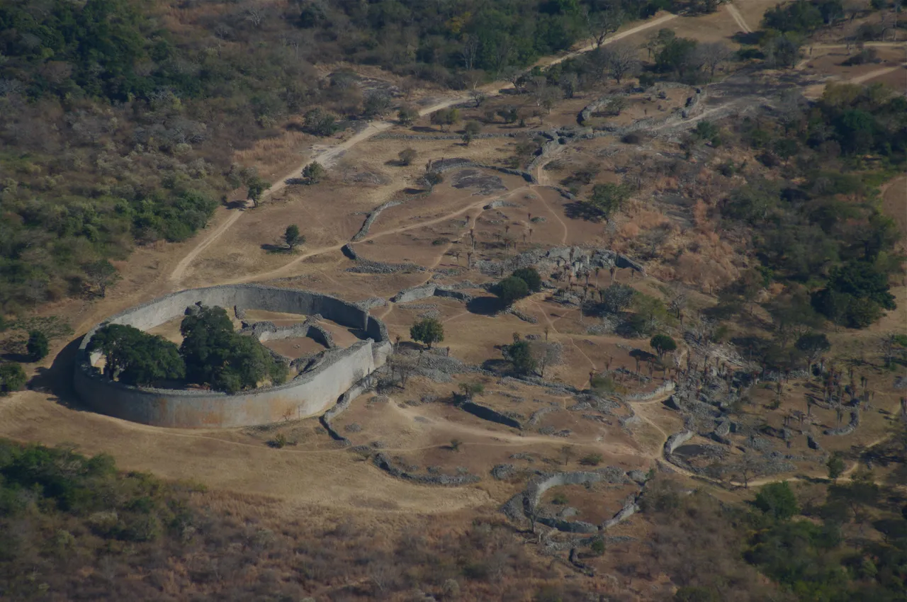
In the valley below stands the Great Enclosure, called Mumbahuru, “the great house,” in Shona, and once known to settlers as the Elliptical Temple.25 Its outer wall is more than 240 meters long and, at its greatest, about 5 meters thick and 10 meters high. Garlake called it “by far the largest single prehistoric structure in sub-Saharan Africa” and cited an estimate that it holds about 182,000 cubic feet of stone, more than the rest of the ruins combined.26 He worked out that 400 laborers, building for 50 days a year between farming seasons, could have finished it in four years.27
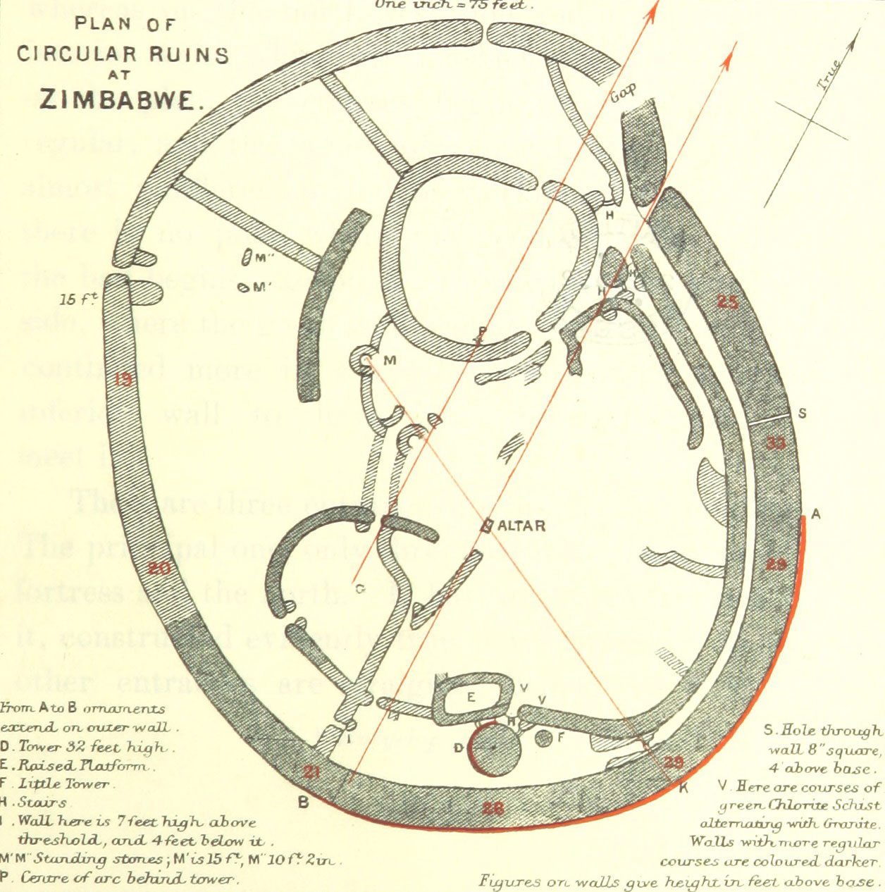
Inside stands the Conical Tower, a solid cone about 5.5 meters across and 9 meters high, decorated near the top with a band of patterned stonework.28 It is solid. Garlake noted its resemblance to a grain bin and suggested it may have symbolized tribute and rule.29
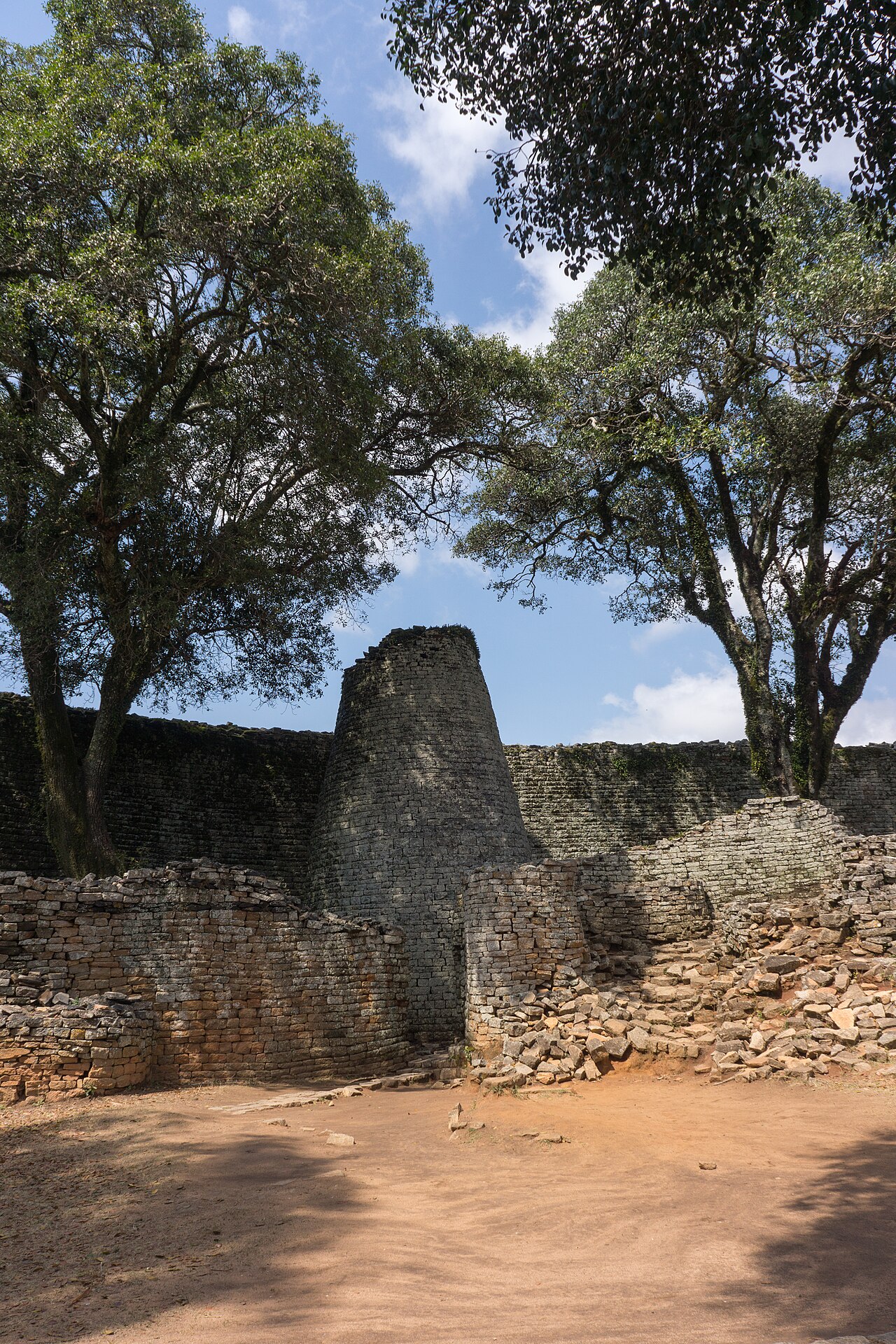
Anthony Whitty sorted the walls into styles he labeled P, PQ, Q and R, with P the older, less regular coursing and Q the finely dressed, regular style, and read them as a sequence in time. Huffman and Vogel later showed that R walling was built alongside the others, and P. J. Walker argued the differences came mostly from the stone quarried, with deeper quarrying giving thicker slabs, rather than from date.30
The walls were not built for war. Garlake found no loopholes, bastions or parapets, entrances without outer defenses, and most enclosures on open ground, often overlooked by hills.31 Inside, people lived in round houses with thick walls of daga, a packed earth mixture, and molded fittings. Walls enclosed courtyards and houses; they were not roofed buildings.32
Many other walled sites across the plateau share the style: Garlake counted 150 to 200 known ruins in the granite country, about a third of them built after Great Zimbabwe declined.33 He suggested that trained teams of masons traveled from Great Zimbabwe to build them.34
What the town made and traded
People at Great Zimbabwe smelted iron and worked copper, bronze and gold on site. They spun cotton: spindle whorls turn up by the hundreds, and appear at about the same time as the stone walls.35 A midden in the Great Enclosure dated to the mid-13th century holds the earliest gold found in the valley.36 A later deposit called the Fireguard Midden, dated to the 15th century, held a gold bead, a gold bar and more than 50 crucible fragments with gold droplets.37
Gold was the export that drew coastal traders. The Save valley gave the easiest route through the eastern mountains toward Sofala, which lay near modern Beira and is generally thought to have been the main port for the interior.38 Trade goods came back up: glass beads from the Middle East, India and Southeast Asia, Chinese celadon, Persian pottery, Near Eastern glass with Arabic writing, cowrie shells and coral.39 Huffman found a small copper coin naming al-Hasan bin Sulaiman, a sultan of Kilwa on the coast of Tanzania, in a midden against the Outer Perimeter Wall.40 Iron gongs of a Central African type and molds for X-shaped copper ingots point to contacts to the north as well.41
The largest find of imports came from the Renders Ruin in the valley. Richard Hall, who dug there in 1903, listed beaten gold and gold wire, engraved Arabian glass, glazed pottery, “a fine copper chain,” “half a hundred-weight of twisted iron wire,” two pairs of double iron gongs, cakes of copper and “two hundred-weight of hoes, axes, and chisels.”42 Other finds from the same ruin include a Persian bowl with an Arabic inscription, a Chinese jade teapot and, in 1941, more than 30,000 glass beads.43
How much the trade mattered is one of the site’s main arguments. From Randall-MacIver in 1906 to Garlake and Huffman, many archaeologists treated control of long-distance trade as the engine of Great Zimbabwe’s wealth.44 Garlake wrote that “no other site in Rhodesia has yielded more than a minute proportion of the imports at Great Zimbabwe.”45 Chirikure counters that the numbers are small: fewer than 120 fragments of celadon and porcelain over about 400 years of occupation, and a single jade teapot. He argues that cattle, land and local trade in iron, copper, salt and grain did more to build the state, and that imports were spread fairly evenly across the site rather than hoarded by an elite.46
The birds
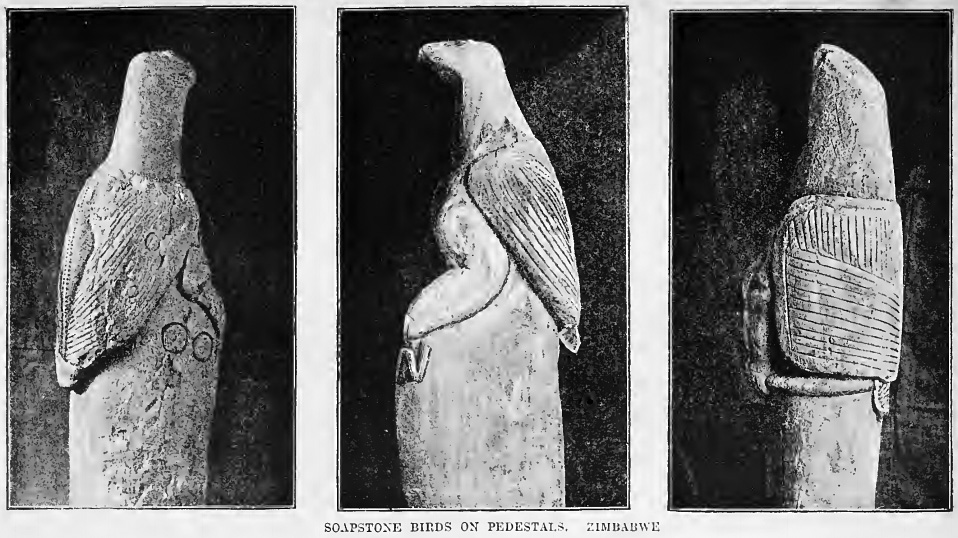
The best-known objects from Great Zimbabwe are its carved soapstone birds. Garlake counted seven, plus the lower half of an eighth, and wrote that “nothing like them has been found anywhere else.” They stand about 36 centimeters tall on top of columns about 90 centimeters high, carved from a dark soapstone whose nearest outcrop is about 24 kilometers away. They are stylized, not any particular species.47
Most came from the Eastern Enclosure on the hill. In 1889 the hunter Willie Posselt saw four there and, despite protests from local people, hacked one from its base; he later sold it to Cecil Rhodes. In 1891 Theodore Bent removed more.48 A clergyman, the Rev. Axenfeld, acquired the lower part of another bird and sold it to the Berlin Museum für Völkerkunde in 1907 for 500 Reichsmark. It has since been returned to Zimbabwe.49
What the birds meant is open. Several scholars read them as emblems of royal ancestors.50 Beach disagreed: he argued the birds and monoliths were “neither worshipped as gods nor revered as symbols of the dead,” and that religion added little to the rulers’ power.51
Who lived where
With no written record from the capital itself, much depends on reading the layout. Garlake saw the finished Great Enclosure as both the main religious focus and the home of the ruler and his circle, with priests, officials and royal relatives in the Valley enclosures and the hill keeping a special sanctity.52 Huffman built a detailed model in which the hill was the king’s quarters, other spaces served ritual and initiation, and the Valley enclosures housed royal wives.53
Chirikure and Innocent Pikirayi reject that model. They argue that the Valley enclosures were the palaces of different kings, built one after another as power passed between branches of the royal family, and that Great Zimbabwe stayed a capital for longer than the standard account allows.54 Huffman and Woodborne answer that none of the Valley ruins matches the pattern of more than 300 recorded palaces, and that this kind of succession only arose in the mid-18th century.55
The size of the town is just as disputed. The walled core covered about 78 hectares at its height, by Huffman and Vogel’s measure, and the protected site today covers 720 hectares.56 Estimates of the population differ more than tenfold, from Garlake’s 1,000 to 2,500 adults to Huffman’s 18,000 people. Much of the evidence that could settle the question was dug away before anyone recorded it.57
Why the capital faded
By the middle of the 15th century, Great Zimbabwe was no longer a seat of power. Huffman and Vogel wrote that it “had lost its economic and political importance to Khami and other centres, although it continued to be inhabited.”58 Why is less clear.
Shona tradition, as Garlake retold it, says the Mbire kingdom ran short of salt, so its ruler, Nyatsimba Mutota, sent people to find it. They found it in the Dande area of the Zambezi valley, and Mutota moved north, conquered the people there and earned the name Mwene Mutapa, which Garlake translated as “Master Pillager.”59 Garlake read the salt shortage as shorthand for failing food supplies and disrupted trade, and saw the Mutapa state as Great Zimbabwe’s direct successor.60
Beach doubted much of this. He noted that Mutota “did not appear in any account as a state-founder before the 1860s,” and concluded that the Mutapa traditions “do not show that there was a direct link between the Zimbabwe and Mutapa states, and certainly not that the last ruler of Zimbabwe was the first Mutapa.”61 Pikirayi calls the traditions about Great Zimbabwe closer to mythology than historical fact.62
Environmental strain is the oldest explanation. Garlake and Beach both argued that a large population wore out the grazing, soil, firewood and game around the town. Beach added that disease must have been a problem in so crowded a place.63 Huffman and Woodborne reject environmental collapse: the district got good rain, and had degradation been the cause, they write, the town “would have been abandoned much earlier.” They blame local politics, as the Torwa rulers at Khami, in the southwest, took control of the gold belt and reopened the trade route along the Limpopo.64 Pikirayi also argues local factors mattered more than distant markets, and suggests that trade demands turned gold mining into a year-round job that competed with farming.65
Chirikure describes the decline as a slow process rather than a single event. He points out that the Mutapa state already existed by 1450, so it cannot simply have been founded by people leaving Great Zimbabwe, and that Great Zimbabwe, Khami and the early Mutapa state overlapped in time.66
People did stay. Chinese blue-and-white porcelain of the late 15th or early 16th century has been found in the Valley, including an almost complete plate excavated by David Collett. A Portuguese-made ceramic copy of a conus shell, an ornament worn by chiefs, suggests that important people were still there in the Portuguese period.67 Huffman and Woodborne interpret the late Valley settlement as a place where royal wives came to give birth, a Shona custom called masungiro; Chirikure calls that reading absurd, since the remains are those of ordinary working homesteads.68
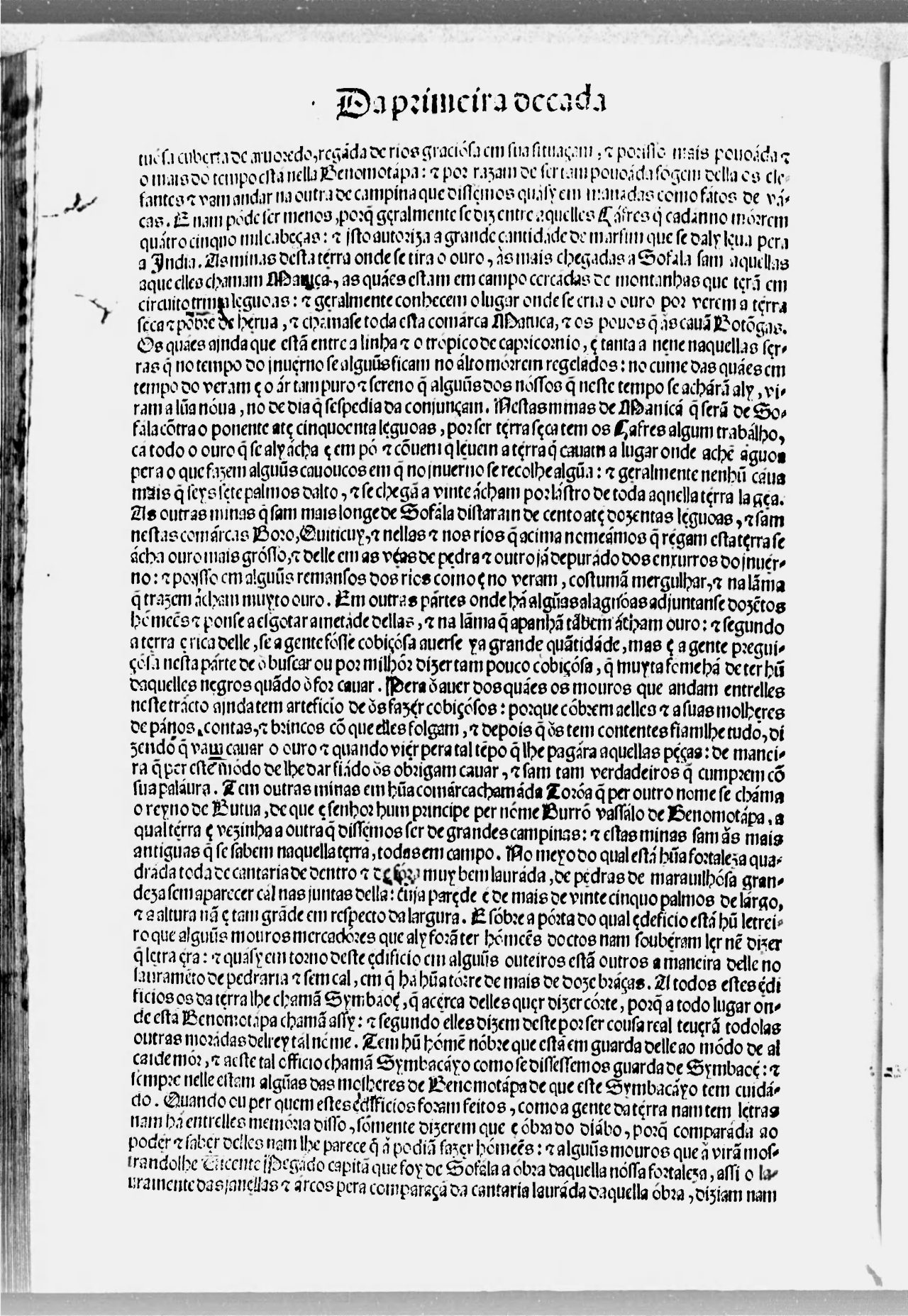
Barros’s account fits the picture of a place still occupied but ruled from elsewhere. Pikirayi notes it was collected at Sofala before 1538 from Swahili traders, some of whom had probably seen the site.69 Beach thought the informant saw the buildings only from a distance, far enough away to mistake the hill walls for a tower and the Great Enclosure for a square.70
After the kings
The successor states kept building in stone. Khami, Danamombe, Naletale and many smaller sites took their masonry skills, wall styles and decoration from Great Zimbabwe.71 The Torwa state at Khami was destroyed in a civil war around 1650, when rivals for the throne allied with the Portuguese, and power passed to Danamombe.72
Great Zimbabwe kept a religious role. According to traditions Garlake collected, the Rozvi never settled there but came to sacrifice every two to four years, driving cattle to the foot of the hill.73 By the 19th century several groups lived around the site, among them the Nemanwa, the Duma under the Mugabe chiefs, and the Charumbira; the Mugabe claim to have been its last residents.74 The ceremonies continued into the colonial period. Hall recorded that “the last sacrifice at Zimbabwe took place in February, 1904,” during a long drought, and that local people kept it private “until after it was over, and the rain had arrived.”75
Chirikure argues the site was never empty. People lived in and around it from the 11th century until the 1800s, their settlements growing and shrinking, and some local groups, such as the Nemanwa, say they originated there.76
How we know
The German geologist Karl Mauch reached the site in 1871 and drew Western attention to it. He found the Great Enclosure deserted and overgrown, and drew on Portuguese speculation about the Queen of Sheba to conclude that the builders came from outside Africa.77 Cecil Rhodes, whose British South Africa Company colonized the country, hired Theodore Bent and later Richard Hall to look for evidence of foreign builders.78
Their digging did lasting damage. Hall removed the top one to two meters of deposit from the Great Enclosure and the Hill Complex in the early 1900s, and in 1915 the Public Works Department shoveled several more meters out of the Western Enclosure without recording what was in it.79 Objects were sold to Rhodes and others and scattered to museums in Cape Town, Bulawayo, Harare, Berlin and London.80
Professional archaeologists overturned the foreign-builder theory. David Randall-MacIver, sent by the British Association for the Advancement of Science, dated the site to the medieval period from its imports in 1906.81 Gertrude Caton-Thompson, excavating for the same body, concluded in 1931 that the evidence could “produce not one single item that is not in accordance with the claim of Bantu origin and medieval date.”82 Settler opinion did not change. Chirikure notes that local people “never doubted Great Zimbabwe’s local origin.”83
Radiocarbon dating from the 1950s onward put the question beyond argument, though the dates themselves remain contested.84 Garlake used imported Chinese ceramics to argue in 1968 that Great Zimbabwe was virtually abandoned by the mid-15th century.85 Beach combined archaeology with Shona tradition and Portuguese records. Since the 1990s, Huffman’s structural model and Chirikure’s and Pikirayi’s alternatives, built on new excavations and about 50 radiocarbon dates, have defined the debate.86
When Zimbabwe became independent on April 18, 1980, it took its name from the site.87 The word is usually explained as a contraction of dzimba dza mabwe, “houses of stone,” though Garlake thought it better derived from dzimba woye, “venerated houses,” a term for chiefs’ houses or graves.88 UNESCO listed Great Zimbabwe as a World Heritage Site in 1986.89
Notes
-
Huffman and Vogel 1991, p. 69 (quoting de Barros, Da Asia, 1552, in Theal’s translation); Pikirayi 2006, pp. 39-40. ↩
-
Huffman and Vogel 1991, p. 69. ↩
-
Pikirayi 2006, pp. 39-40; Huffman and Vogel 1991, p. 69; Beach 1980, p. 191. ↩
-
Chirikure 2021, pp. 26-28, 37. ↩
-
Chirikure 2021, pp. 38, 245; Pikirayi 2006, p. 35. ↩
-
Chirikure 2021, p. 42; Huffman and Vogel 1991, p. 63. ↩
-
Chirikure 2021, p. 42. ↩
-
Beach 1980, pp. 40-41. ↩
-
Chirikure 2021, pp. 96, 205-206. ↩
-
Huffman and Vogel 1991, pp. 64-65, 69; Chirikure 2021, p. 229. ↩
-
Chirikure et al. 2014, p. 1. ↩
-
Garlake 1973, pp. 183-184. ↩
-
Beach 1980, p. 42. ↩
-
Chirikure 2021, pp. 230-232; Huffman and Woodborne 2020, p. 87. ↩
-
Chirikure 2021, pp. 227-228, 239-240. ↩
-
Chirikure 2021, pp. 234-235. ↩
-
Beach 1974, p. 11, quoted in Chirikure 2021, p. 233. ↩
-
Chirikure 2021, p. 80; Huffman and Vogel 1991, p. 61. ↩
-
Huffman and Vogel 1991, p. 69. ↩
-
Huffman and Woodborne 2020, pp. 86-87, 106. ↩
-
Garlake 1973, pp. 183, 202. ↩
-
Chirikure 2021, pp. 11, 18. ↩
-
Garlake 1973, pp. 24-26; Chirikure 2021, pp. 34-35. ↩
-
Chirikure 2021, p. 68; Huffman and Vogel 1991, p. 66. ↩
-
Chirikure 2021, pp. 9, 34-35. ↩
-
Garlake 1973, p. 27. ↩
-
Garlake 1973, p. 195. ↩
-
Garlake 1973, p. 29. ↩
-
Garlake 1973, p. 122. ↩
-
Chirikure 2021, pp. 95-96; Huffman and Vogel 1991, pp. 66-67. ↩
-
Garlake 1973, p. 183. ↩
-
Garlake 1973, pp. 117-118; Chirikure 2021, pp. 34-35. ↩
-
Garlake 1973, p. 196. ↩
-
Garlake 1973, p. 197. ↩
-
Garlake 1973, pp. 111-117. ↩
-
Huffman and Vogel 1991, p. 65. ↩
-
Chirikure 2021, p. 91. ↩
-
Chirikure 2021, pp. 217-218; Garlake 1973, pp. 184, 193; Pikirayi 2006, p. 31. ↩
-
Chirikure 2021, pp. 204, 208-210; Pikirayi 2006, p. 37. ↩
-
Huffman and Woodborne 2020, p. 95; Chirikure 2021, pp. 67, 212-213. ↩
-
Chirikure 2021, pp. 213-214. ↩
-
Hall 1905, pp. 387-388. ↩
-
Garlake 1973, pp. 131-133; Chirikure 2021, pp. 207, 210-212. ↩
-
Chirikure 2021, pp. 236-237. ↩
-
Garlake 1973, p. 194. ↩
-
Chirikure 2021, pp. 216, 238-239. ↩
-
Garlake 1973, pp. 119-120. ↩
-
Garlake 1973, p. 119; Chirikure 2021, pp. 66, 71; Hall 1905, p. 106. ↩
-
Chirikure 2021, p. 72. ↩
-
Chirikure 2021, p. 228. ↩
-
Beach 1980, pp. 44-46. ↩
-
Garlake 1973, p. 197. ↩
-
Chirikure 2021, p. 12; Huffman and Vogel 1991, p. 68. ↩
-
Huffman and Woodborne 2020, p. 105; Pikirayi and Chirikure 2011, p. 221. ↩
-
Huffman and Woodborne 2020, p. 105. ↩
-
Huffman and Vogel 1991, p. 61; Chirikure 2021, p. 26. ↩
-
Garlake 1973, p. 195; Huffman and Woodborne 2020, pp. 103-104; Huffman and Vogel 1991, p. 67. ↩
-
Huffman and Vogel 1991, p. 69. ↩
-
Garlake 1973, p. 175. ↩
-
Garlake 1973, pp. 179, 198-199. ↩
-
Beach 1980, pp. 61, 63. ↩
-
Pikirayi 2006, p. 40. ↩
-
Garlake 1973, p. 198; Beach 1980, pp. 46, 50-51. ↩
-
Huffman and Woodborne 2020, p. 105. ↩
-
Pikirayi 2006, pp. 38, 41. ↩
-
Chirikure 2021, pp. 43, 246, 249. ↩
-
Huffman and Vogel 1991, p. 68; Chirikure 2021, pp. 97-98, 208-209, 246. ↩
-
Huffman and Woodborne 2020, pp. 105-106; Chirikure 2021, pp. 248-249. ↩
-
Pikirayi 2006, pp. 39-40. ↩
-
Beach 1980, p. 191. ↩
-
Garlake 1973, p. 180. ↩
-
Chirikure 2021, p. 236. ↩
-
Garlake 1973, p. 180. ↩
-
Chirikure 2021, pp. 43-44, 242. ↩
-
Hall 1905, p. 93. ↩
-
Chirikure 2021, pp. 102-103, 242. ↩
-
Chirikure 2021, pp. 8, 66; Garlake 1973, p. 180. ↩
-
Chirikure 2021, pp. 7-8, 57. ↩
-
Huffman and Vogel 1991, p. 67; Chirikure 2021, pp. 67, 81-82. ↩
-
Chirikure 2021, pp. 8, 71-72, 209. ↩
-
Chirikure 2021, pp. 8, 79. ↩
-
Garlake 1973, p. 201; Chirikure 2021, p. 8. ↩
-
Chirikure 2021, p. 8. ↩
-
Huffman and Vogel 1991, p. 69; Chirikure 2021, pp. 80, 98. ↩
-
Huffman and Vogel 1991, p. 62; Chirikure 2021, p. 80. ↩
-
Chirikure 2021, pp. 12, 98. ↩
-
Chirikure 2021, pp. 4, 13. ↩
-
Garlake 1973, p. 11. ↩
-
Chirikure 2021, p. 26. ↩
Where the estimates differ
| Estimate | Who holds it | Source |
|---|---|---|
| About 1275 to about 1450, less than 200 years | Thomas Huffman and J. C. Vogel | Huffman and Vogel 1991, p. 69 |
| About 1285 to 1450, with the peak from about 1395 | Thomas Huffman and Stephan Woodborne, from AMS dates | Huffman and Woodborne 2020, pp. 86-87 |
| About 1200 to 1450 | Peter Garlake | Chirikure 2021, p. 80; Garlake 1973, pp. 182-183, 197-198 |
| A state forming after about 1100, well advanced by about 1300, ending in the second half of the 1400s | D. N. Beach | Beach 1980, pp. 41, 44, 50 |
| The 11th or 12th century to the 16th, perhaps the 17th | Shadreck Chirikure | Chirikure 2021, p. 240 |
| Estimate | Who holds it | Source |
|---|---|---|
| 1,000 to 2,500 adults | Peter Garlake, from hut counts in excavated enclosures | Garlake 1973, p. 195 |
| 5,000 to 11,000, perhaps more | D. N. Beach, summarizing estimates of his time | Beach 1980, p. 46 |
| About 18,000, half of them children | Thomas Huffman (1986), reaffirmed with Stephan Woodborne | Huffman and Woodborne 2020, p. 104; Huffman and Vogel 1991, p. 61 |
| Up to 20,000 at the 14th-century peak | Innocent Pikirayi | Pikirayi 2006, p. 32 |
| 1,148 to 2,009 under one model, 228 to 399 under another | Shadreck Chirikure and colleagues (2017), as reported by Huffman and Woodborne, who reject both | Huffman and Woodborne 2020, pp. 103-104 |
| Estimate | Who holds it | Source |
|---|---|---|
| Too many people for the land around it, then a move north that founded the Mutapa state | Peter Garlake | Garlake 1973, pp. 198-199 |
| Environmental strain from a large population, perhaps with drought or civil war | D. N. Beach | Beach 1980, pp. 50-51 |
| Local politics: the Torwa state at Khami took over the gold belt and the trade route | Thomas Huffman and Stephan Woodborne | Huffman and Woodborne 2020, p. 105 |
| Local rather than global factors, including gold mining that came to compete with farming | Innocent Pikirayi | Pikirayi 2006, pp. 38, 41 |
| A slow process with several causes; the town shrank from the mid-1500s rather than collapsing | Shadreck Chirikure | Chirikure 2021, pp. 241-249 |
Timeline
- c. 1275 Great Zimbabwe emerges
- c. 1275 Capital at Great Zimbabwe
- c. 1450 Great Zimbabwe stops being the seat of power; people go on living there into the 1500s and later
Correction
Our Great Zimbabwe overview has moved into the new Great Zimbabwe page, and it overstated several figures.The overview at /history/articles/great-zimbabwe-medieval-stone-city-fight/ now redirects to the new state page. It gave a population of 10,000 to 20,000 as a settled range; published estimates run from Garlake's 1,000 to 2,500 adults to Huffman's 18,000 people, and they are still disputed (Garlake 1973, p. 195; Huffman and Woodborne 2020, pp. 103-104). It said excavations found 14th-century Arab coins; one copper coin of a Kilwa sultan has been reported, and its date is disputed between sources (Huffman and Woodborne 2020, p. 95). Its figures of 11 meters high and 250 meters long for the Great Enclosure wall could not be matched to a scholarly source; Garlake gives more than 800 feet long and up to 32 feet high (Garlake 1973, p. 27). We could not find its quotation of Gertrude Caton-Thompson rejecting a "degenerate off shoot of a higher Oriental civilization" in the sources we consulted, and have not repeated it. The new page sets out the competing estimates side by side.Corrected in September 2026. See the log entry.
Sources
- Shadreck Chirikure. “Great Zimbabwe: Reclaiming a 'Confiscated' Past”, Routledge, 2021.
- Peter S. Garlake. “Great Zimbabwe”, Thames and Hudson, 1973.
- D. N. Beach. “The Shona and Zimbabwe 900-1850”, Heinemann / Mambo Press, 1980.
Further Reading
The sources above support the specific claims on this page. The works below are the scholarship behind them. Citations are given in full so readers can find them through a library or database; some are paywalled.
Peer-reviewed articles
- Chirikure, Shadreck (2020). "New Perspectives on the Political Economy of Great Zimbabwe." Journal of Archaeological Research 28(2): 139-186. DOI: 10.1007/s10814-019-09133-w.abstract free
- Chirikure, Shadreck; Pikirayi, Innocent (2008). "Inside and outside the dry stone walls: revisiting the material culture of Great Zimbabwe." Antiquity 82(318): 976-993. DOI: 10.1017/S0003598X00097726.abstract free
- Chirikure, Shadreck et al. (2018). "Elites and commoners at Great Zimbabwe: archaeological and ethnographic insights on social power." Antiquity 92(364): 1056-1075. DOI: 10.15184/aqy.2018.137.abstract free
- Chirikure, Shadreck et al. (2013). "A Bayesian chronology for Great Zimbabwe: re-threading the sequence of a vandalised monument." Antiquity 87(337): 854-872. DOI: 10.1017/S0003598X00049516.abstract free
- Huffman, Thomas N.; Vogel, J. C. (1991). "The Chronology of Great Zimbabwe." The South African Archaeological Bulletin 46(154): 61-70. DOI: 10.2307/3889086.abstract free
- Huffman, Thomas N.; Woodborne, Stephan (2020). "AMS Dates and the Chronology of Great Zimbabwe." Journal of African Archaeology 18(1): 86-108. DOI: 10.1163/21915784-20200006.abstract free
- Pikirayi, Innocent (2006). "The demise of Great Zimbabwe, AD 1420-1550: an environmental re-appraisal." Cities in the World 1500-2000 (Society for Post-Medieval Archaeology Monograph 3), ed. A. Green and R. Leech null: 31-47.
- Collett, D. P.; Vines, A. E.; Hughes, E. G. (1992). "The chronology of the Valley Enclosures: implications for the interpretation of Great Zimbabwe." The African Archaeological Review 10(1): 139-161. DOI: 10.1007/BF01117699.abstract free
- Chirikure, Shadreck et al. (2014). "Zimbabwe Culture before Mapungubwe: New Evidence from Mapela Hill, South-Western Zimbabwe." PLoS ONE 9(10): e111224. DOI: 10.1371/journal.pone.0111224.
- Pikirayi, Innocent (2013). "Stone architecture and the development of power in the Zimbabwe tradition AD 1270-1830." Azania: Archaeological Research in Africa 48(2): 282-300. DOI: 10.1080/0067270X.2013.789225.
- Pikirayi, Innocent; Chirikure, Shadreck (2011). "Debating Great Zimbabwe." Azania: Archaeological Research in Africa 46(2): 221-231. DOI: 10.1080/0067270X.2011.580149.
- Pikirayi, Innocent et al. (2016). "Great Zimbabwe's water." WIREs Water 3(2): 195-210. DOI: 10.1002/wat2.1133.
- Walker, P. J. (1993). "The Architectural Development of Great Zimbabwe." Azania: Archaeological Research in Africa 28(1): 87-102. DOI: 10.1080/00672709309511649.abstract free
- Chirikure, Shadreck et al. (2017). "What was the population of Great Zimbabwe (CE 1000-1800)?." PLoS ONE 12(6): e0178335. DOI: 10.1371/journal.pone.0178335.
- Pikirayi, Innocent (2017). "Ingombe Ilede and the demise of Great Zimbabwe." Antiquity 91(358): 1085-1086. DOI: 10.15184/aqy.2017.95.abstract free
- Garlake, P. S. (1968). "The Value of Imported Ceramics in the Dating and Interpretation of the Rhodesian Iron Age." The Journal of African History 9(1): 13-33. DOI: 10.1017/S0021853700008331.abstract free
Books
- Pikirayi, Innocent (2001). The Zimbabwe Culture: Origins and Decline in Southern Zambezian States. AltaMira Press.
- Huffman, Thomas N. (2007). Handbook to the Iron Age: The Archaeology of Precolonial Farming Societies in Southern Africa. University of KwaZulu-Natal Press.
- Caton-Thompson, Gertrude (1931). The Zimbabwe Culture: Ruins and Reactions. Clarendon Press, Oxford.
- Thorp, Carolyn R. (1995). Kings, Commoners and Cattle at Zimbabwe Tradition Sites. National Museums and Monuments of Zimbabwe (Museum Memoir, New Series No. 1).
- Hall, R. N. (1905). Great Zimbabwe. Methuen, London.
More on Great Zimbabwe
Great Zimbabwe: c. 1275 to c. 1450.